The Western Australian Planning Commission (WAPC) approved Amendment No. 38 to the East Wanneroo Cell 4 Approved Structure Plan No. 6 on 17 July 2023. A timeline of the project can be found below.
October 2025 — Amendment No. 41
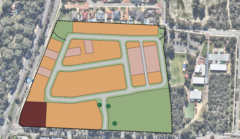
The City received an amendment from the developers regarding changes to the East Wanneroo Cell 4 Agreed Structure Plan (Amendment No. 41).
Main Purpose: The amendment proposes to rezone the western portion of the site, which adjoins Wanneroo Road, from 'Special Use Zone' to 'Residential Purpose'.
Reason: The 'Special Use Zone' was originally intended to accommodate commercial development, but the prospective purchaser intends to develop the entire vacant portion of the site for residential use.
Density: The Structure Plan map legend will be updated to change the density designation from 'R25-60' to 'R30-R60', establishing a base density of R30 for new lots.
The City of Wanneroo was inviting public comment on this proposal. Consultation Period: Submissions were open from 15 October 2025 until 29 November 2025.
October 2025 — Subdivision & Acquisition
The WAPC approved a green title subdivision to separate the school from the remainder of the site and to create a lot aligned with the Special Use Zone fronting Wanneroo Road.
Recently, Land Group was successful in acquiring the site. The current owners are now progressing with the subdivision clearance to create Lot 9000, enabling settlement to proceed.
View Deposited Plan →
July 2023 — Post-Settlement Plans
Following the settlement, Land Group intends to pursue a residential subdivision over the site. While no formal application had been submitted to the WAPC yet, a preliminary meeting between Administration and Land Group was held. It was indicated that the proposed subdivision would generally align with the concept plan included in the approved Local Structure Plan for the site. The Department amended the proposal which was approved on 17 July 2023.
August 2020 — Council Recommendation
Council's recommendation on the matter was forwarded to the Department of Planning Lands and Heritage (DPLH) in August 2020. Construction start time unknown.
What works are currently taking place?
The developer is currently performing bulk earthworks within the subdivision site as part of a WAPC-approved project.
When will the sewer works and road closures begin?
Sewer infrastructure works are scheduled to commence on Monday, 30 March 2026. This will necessitate a temporary road closure. The timing was selected to coincide with the school holiday period to minimise peak traffic impacts.
Are the closures to Tenement Loop permanent?
No. Any information suggesting permanent closures is incorrect. The closures are temporary to facilitate the installation of sewer infrastructure.
Why was the notification for current works so late?
TRACC Civil overlooked the requirement for letterbox drops due to a change in Project Supervisor. Notifications were not distributed until Wednesday, 25 March 2026. Schools were notified 2–3 weeks in advance; Variable Message Boards were installed on Wanneroo Road; and Notices were published in the PeTime on 9 March 2026.
Who approved the subdivision at Lot 594?
The Western Australian Planning Commission (WAPC) is the determining authority that approved the subdivision and the associated structure plan amendments. The City of Wanneroo provides recommendations to the WAPC, but the final decision-making power rests with the State Government body.
What was the original plan for the site vs. what is being built?
The site was originally intended for "Special Use," which could have included high-traffic businesses like fast food with drive-throughs and service stations. The developer successfully applied to change this to a primarily residential subdivision.
How does the move to residential development affect local traffic?
The shift from commercial "Special Use" to residential is expected to significantly reduce traffic impact. Original projections for commercial use estimated 3,500 vehicle trips per day; the new residential plan is projected to generate only about 500 trips per day — a reduction of 3,000 trips.
Why were established trees outside the site removed?
The City is investigating why these removals occurred without the promised warning to residents. The subdivision has been updated to remove the road interfacing with the western boundary of St Elizabeth's Primary School, changed to a Public Access Way to allow for the retention of more trees and provide a landscaped pathway between the Conservation Reserve and Ranworth Road. This was a win-win outcome for the developer and the community — less road pavement and more tree canopy.
What is the deal with the orange tape on trees?
Typically, green markers indicate retention, while orange or red markers often denote removal or boundary lines for construction. While the plan designates specific Significant Black Cockatoo Trees for retention, some vegetation must be cleared to facilitate driveways and the required 6.8m Asset Protection Zone (APZ) for fire safety. The flagging was being undertaken as part of the arborist/vegetation assessment, and no trees were to be removed at that stage. Only trees impacted by subdivision works and sewer upgrades/connections will be removed.
How will the City manage the danger of more driveways on Kirkstall Drive?
A mini four-way roundabout will be installed at the intersection of Kirkstall Drive and the main subdivision entrance (opposite Tenement Loop). This is specifically designed to slow traffic and provide a safer entry/exit point for both new and existing residents.
Is the traffic really going to get worse?
No — the current residential plan is projected to generate 3,000 fewer vehicle trips per day than the commercial "Special Use" zoning previously approved for the site. The plan also includes a consolidated pedestrian access way in the north-west, providing a safe route along a newly landscaped reserve to the bus stop on Wanneroo Road.